
TL;DR: The Douyin channel “花花有话说” (Huahua Has Something to Say) 17-minute Part 2 of Operation Python: The Last Stand on Takur Ghar is not made from scratch—frame-by-frame comparison strongly suggests it was lifted from the YouTube channel The Operations Room’s video on the same topic (overall confidence ~0.86); while “神秘园 SMY”’s cave exploration commentary is original 3D map visualizations combined with publicly available material. Both belong to the same content type—narrative map-driven video—but one runs on a relocation pipeline and the other on a self-production pipeline. If you want to replicate, replicate the latter.
Starting Point: A Shared Link
A friend sent over a Douyin share link to “花花有话说”’s Operation Python: The Last Stand on Takur Ghar, Part 2 , tagged with #Military #Afghanistan #NavySEALs. He asked two questions: which YouTube video is this originally from? And what type does it belong to, alongside the cave exploration commentaries by “神秘园”, and could it be replicated?
Operation Anaconda was a U.S. military offensive launched in March 2002 in Afghanistan’s Shah-i-Kot Valley. The battle on Takur Ghar—later known as Roberts Ridge—was among its bloodiest: a helicopter was struck by an RPG and crashed on the ridgeline, trapping the crew and rescue special operators; Air Force Combat Controller John Chapman died on that mountain summit and was posthumously awarded the Medal of Honor.
English-language sources on this history are abundant. For any Chinese解说 video on the topic, where the footage comes from is the key to judging “original or repurposed”.
Method: Download → Frame Extraction → Comparison
My verification process mirrors a data engineering pipeline—three steps:
Step 1: Download the video. Douyin’s CDN has Argus anti-bot protections; ordinary curl and yt-dlp get blocked with “Fresh cookies needed”. I reused the Playwright login session from the OpenClaw toolbox (douyin-state.json), called the /aweme/v1/web/aweme/detail/ API within the browser context to get the direct play_addr link, and downloaded it with the proper Referer header—168MB, 1080p, 30fps, 1019 seconds, success on the first try.
Step 2: Frame-by-frame slicing. I used ffmpeg to extract at 1fps, yielding 1020 frames; then sampled one frame every 5 seconds to compose 6 contact sheets (each cell annotated with the timestamp), and fed each image to a vision model for material composition analysis. This is a lightweight version of the video2script project’s “three-channel extraction” approach: the video is a temporary processing object; the structured information extracted from it is the real asset.
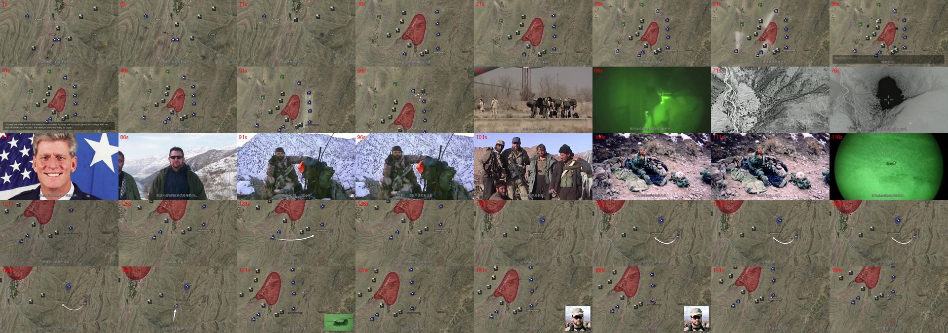
This contact sheet is the raw material for analysis—202 cells compressed into a single image, making the distribution of material types immediately visible: large swaths of repeating brownish terrain maps form the main axis, with穿插 of portrait photos and night-vision footage. All the subsequent numbers about “maps occupying 70–80%” were counted from this kind of composite.
Step 3: Find the source video for comparison. Among English channels specializing in animated military history commentary, The Operations Room has a 51-minute Medal of Honor - The Heroic Last Stand of John Chapman - Operation Anaconda —the same mountain, the same battle. I downloaded its first 10 minutes, extracted frames the same way, and then ran a dual-image comparison through the vision model.
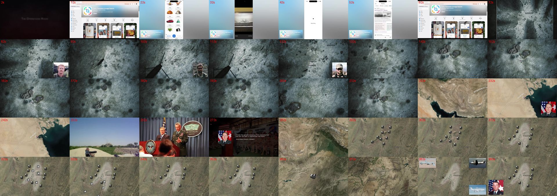
Lay the two composites side by side and the common origin is apparent even without frame-by-frame alignment: identical satellite textures, identical icon density, identical red-and-blue annotation logic.
Military Commentary: Three Numbers Deconstructed
Frame-by-frame statistics for the Douyin video (first 200 seconds sampled, vision model judgment):
- Animated battle maps: 70–80% — satellite terrain base + semi-transparent red enemy zones + blue-white unit icons + curved arrows, with icons and arrows appearing progressively in sync with the narration
- Archival photographs: 10–15% — Chapman portrait (U.S. flag in background), unit group photos, fallen soldier photos
- Archival footage: 5–10% — green night-vision, grayscale aerial/thermal imaging
- AI-generated imagery: 0%, gameplay footage: 0% — no high-frequency AI military-artifacts like malformed gun anatomy or distorted fingers, no HUD crosshairs of any kind
Zooming into a single complete frame makes the details clearer. At the 150-second mark, this is the archetypal frame of the entire video:
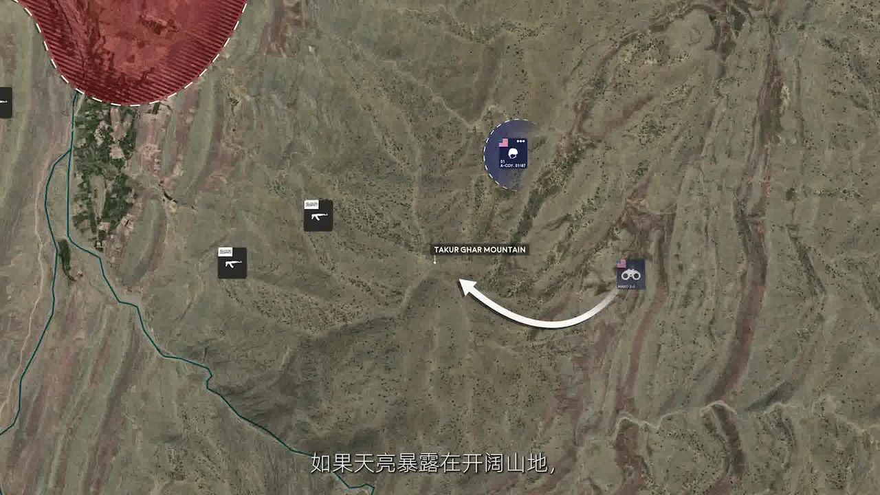
Note three elements: the English place name TAKUR GHAR MOUNTAIN labeled on the terrain map (the original English label preserved verbatim—a telltale fingerprint of repurposing; a self-produced animation by a Chinese channel would typically translate or provide bilingual labels); a semi-transparent red area in the upper left marking enemy-controlled zone; and Chinese commentary subtitles overlaid at the bottom of the frame. The overlay structure—English original layer + Chinese subtitle track—is itself the standard morphology of a translated repurposing video.
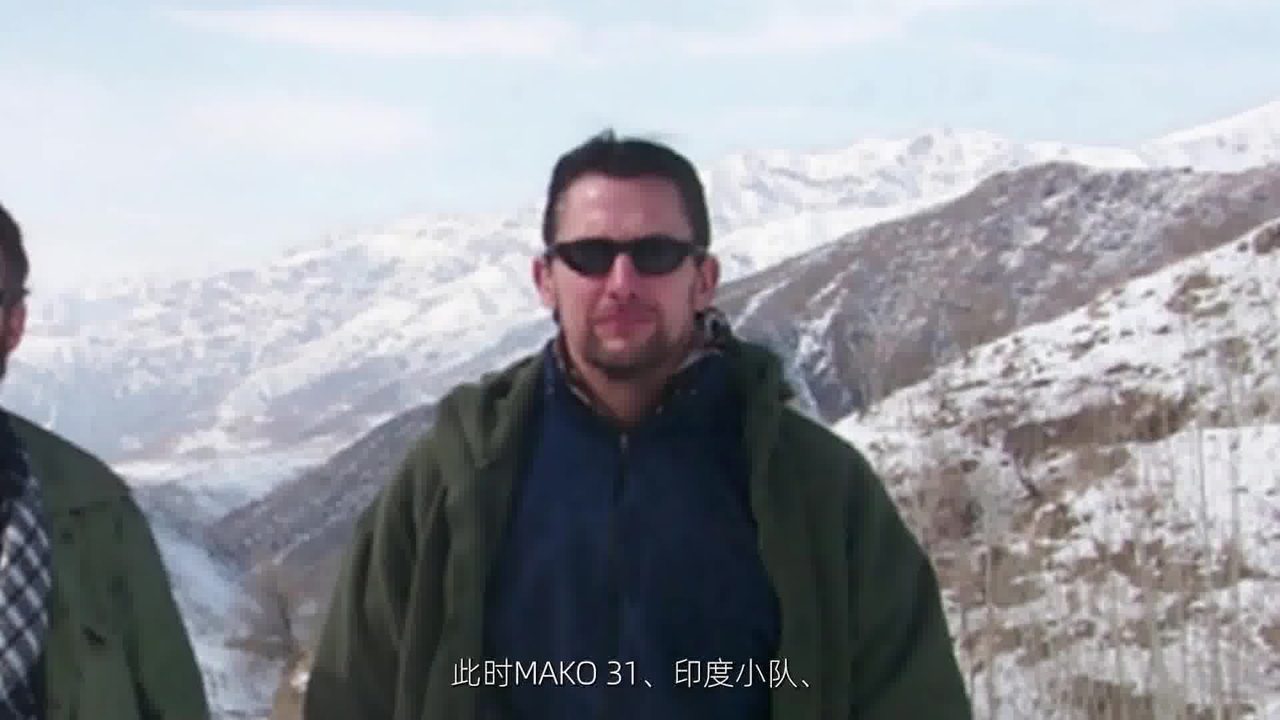
The handling in the personnel introduction section is the same: the original frame (in this shot, a sunglasses-wearing operator standing before a snow-covered mountain valley, describing the deployment of the MAKO 31 recon team) is used directly, with Chinese subtitles overlaid below. As the narrator mentions each team, the subtitle highlights that team.
On its own, this only establishes that the video is a standard “animated map military history commentary.” The definitive evidence comes from the dual-image comparison—the Douyin video versus The Operations Room’s video on the same subject:
| Comparison Item | Finding | Confidence |
|---|---|---|
| Map base maps same region, same style | Yes | 0.85 |
| Icons / arrows / color scheme | Highly consistent or imitation | 0.88 |
| Portrait photo batch overlap (incl. Chapman portrait) | Likely overlapping | 0.75 |
| Suspected source-repurpose translation | Confirmed | 0.86 |
The decisive detail: both videos’ maps share the same visual language—“brownish satellite texture + blue-white friendly icons + semi-transparent red enemy zones + clean curved arrows.” The Douyin version’s red态势 areas closely match the tactical maps in the latter half of The Operations Room video in both shape and position. This goes beyond “same event, similar maps.” It’s closer to the same set of visualization assets being translated, re-edited, and dubbed over with a Chinese narration track.
Placing the map frames from both sides side by side, the similarity exceeds the bounds of “style inspiration”:
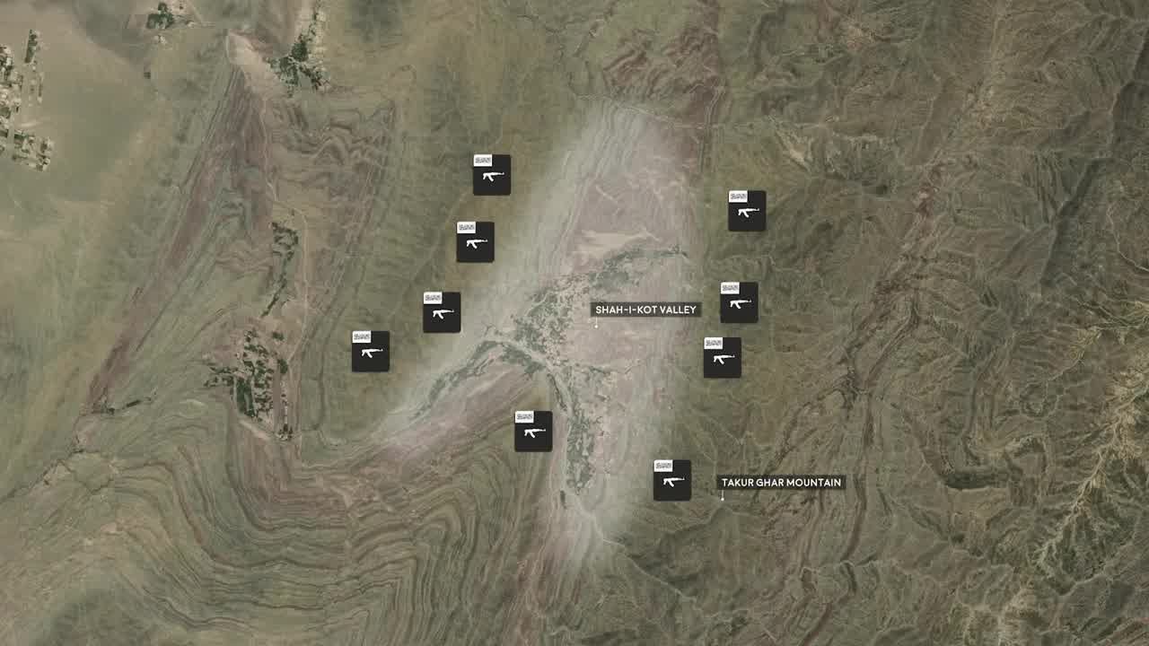
This is a frame from The Operations Room’s map: black squares denote weapon position icons, with English labels marking SHAH-I-KOT VALLEY and TAKUR GHAR MOUNTAIN—the place-name spelling, annotation placement, and icon style correspond exactly to the Douyin frame at 150 seconds above. The sole difference is that the Douyin version has Chinese commentary subtitles. Same battlefield, same vantage point, same military symbology vocabulary—two independent production lines would not produce results this precise by coincidence.
Another piece of evidence lies in the channel bio: “花花有话说”’s signature reads “I don’t make the materials; they come from various big shots across the internet.” The creator themselves confirmed the footage is not self-produced.
So the answer to the first question: the English source for this type is The Operations Room (alongside a cluster of animated war-history channels such as Kings and Generals, Armchair Historian, Battle Order). The dominant production model for Chinese short-form military commentary is to take these channels’ finished products, translate, repackage—re-dub, re-cut pacing, split into parts. The original language is, unequivocally, English.
神秘园: Same Type, Different Approach
神秘园 SMY (Bilibili profile, Douyin homepage) is a top-tier creator in the adventure-accident commentary niche, having gained over a million followers across platforms. Its Douyin single-month growth of 4M+ followers was also analyzed by industry media. Its选题 focus on cave diving, caving expeditions, hiking accidents, extreme outdoor pursuits—a Tencent News assessment described it as “the cave exploration videos constantly bringing bad news have become internet top-tier side dishes for meals.”
I downloaded one of its recent videos ( 10 Hikers on Xinjiang’s XiaTa Ancient Trail, 1 Dead 1 Missing , 11 minutes, distributed across Bilibili, YouTube, and Douyin) and performed the same frame-by-frame breakdown:
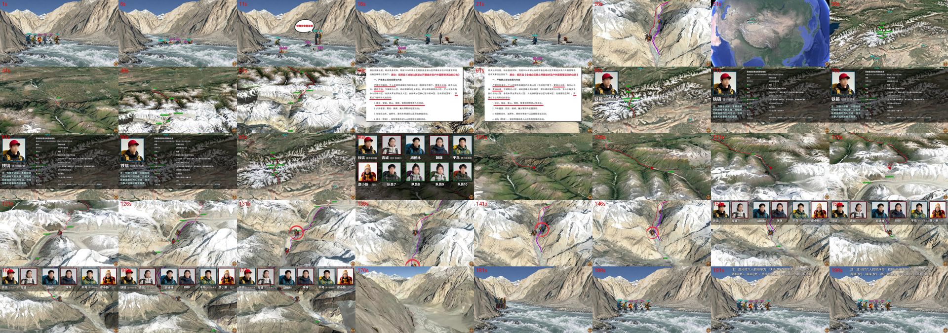
- 3D terrain map animations: 55–65% — Google Earth-style satellite terrain, camera flying in from macro region to specific valley, route segments lighting up progressively, red circles for geolocation
- Schematic animations / infographics: 15–20% — participant portrait arrays, character profile cards, semi-transparent black info boxes, red-circle annotations
- News / official bulletin screenshots: 8–12% — white-background announcements with red highlights, creating a “grounded in facts” feel
- Real footage / scene material: 10–15% — snow-capped mountains, river valley atmosphere shots
Zooming into a single frame to see the signs of self-production. At the 100-second mark, the “character roster” card of the entire video:
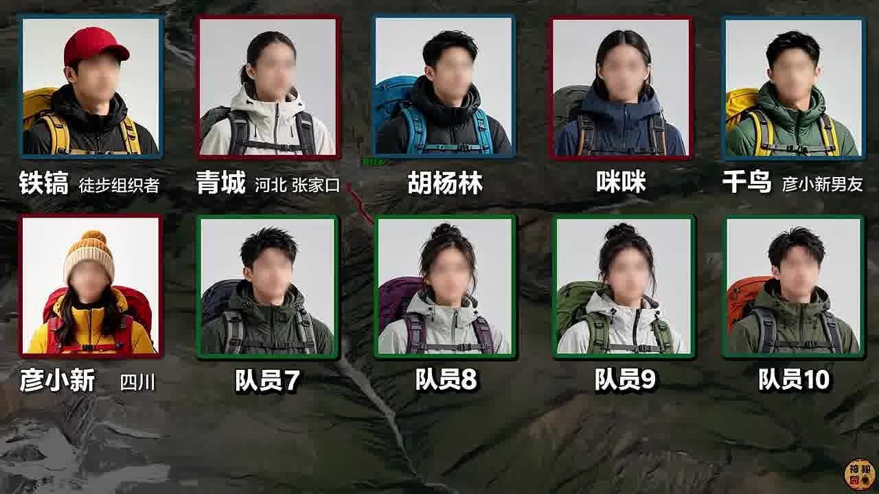
Ten member portraits arranged in two rows, with avatar borders color-coded red / blue / green to distinguish team groupings, each person’s name and role labeled below, set against a darkened terrain-map background. This is a textbook self-produced infographic—the source photos may come from public domains, but the portrait array layout, color-coding scheme, and annotation system are the channel’s own design language, with no counterpart in the military video above.
At the 200-second mark, the video enters a pure map-narration segment:
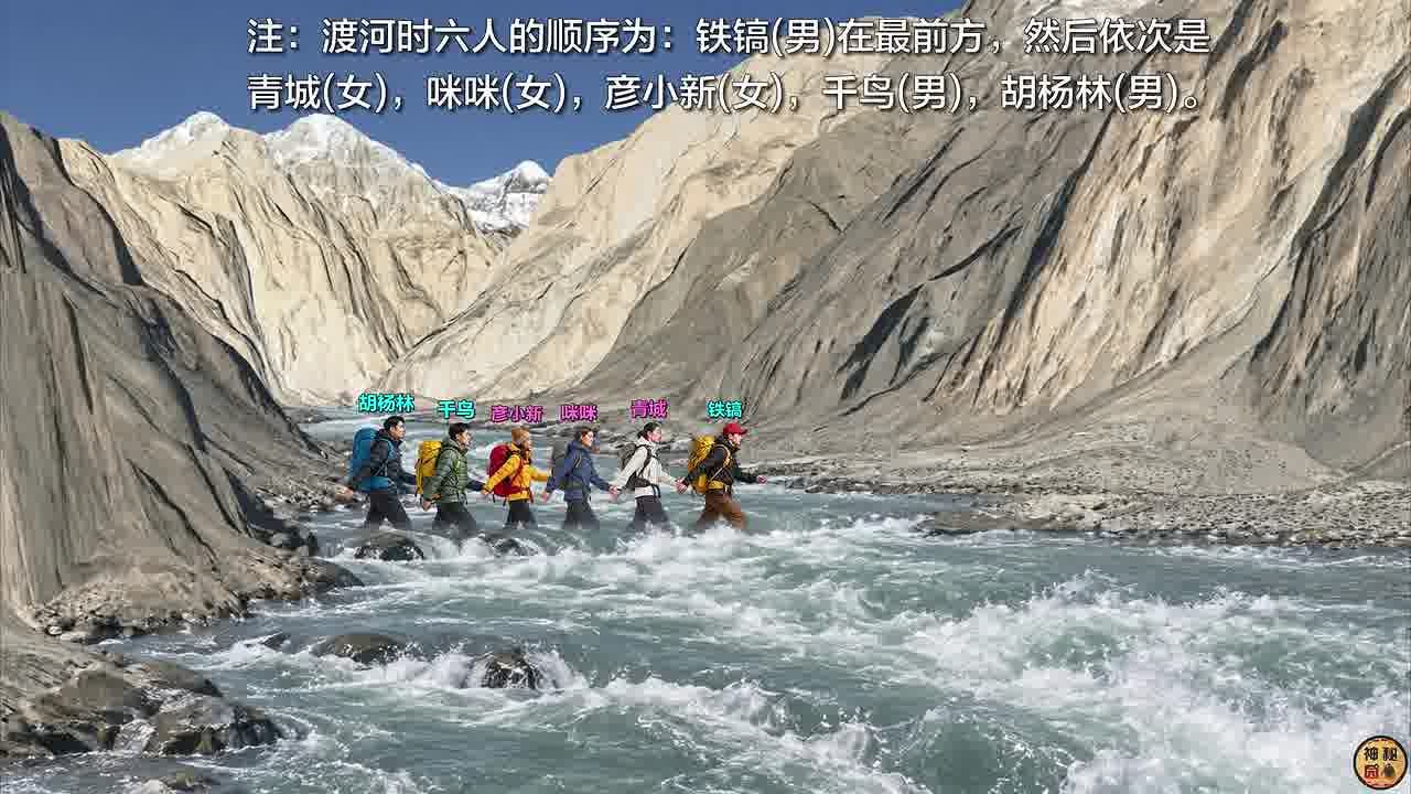
The key difference from the military video is visible in this frame: all map annotations are in Chinese. The route lighting sequence follows the Chinese narration, and place names, units, and legends are all reworked for a Chinese-speaking audience—rather than leaving English labels in place and covering them with translated subtitles. This is the frame-level boundary between “self-produced” and “repurposed.”
The judgment is the opposite of the military video: original. The map animation camera paths, route designs, and character annotation system are the channel’s own creation (base maps sourced from mapping platforms, which is standard material usage). The narrative structure follows the standard “accident after-action review” format: opening hook → character roster → timeline progression → key节点放大 → outcome and reflection. Narration-driven, with visuals following the narration.
The dividing line between the two production lines within the same type is right here: are the visualization assets self-made, or are they someone else’s finished product?
What Type Are They?
In the content industry, these two categories are actually the same species. I call them narrative map-driven videos. Key characteristics:
- Visuals don’t carry the narrative; narration does. Every shot is a visual aid for the narration—where the narration goes, the map advances.
- Maps are the primary narrative vehicle, occupying 50%+ of screen time, using spatial relationships (who is where, which direction they’re moving, what surrounds them) to generate tension.
- Real素材 as the evidence layer: archival photos, news screenshots, and night-vision footage穿插 to create credibility.
- Ken Burns pans: slow zooms and pans on static images to mask the fact that there’s essentially no live-action footage.
- 题材 naturally carries death and suspense: combat, accidents, rescue—every story is a narrative of desperation.
The mature English-language spectrum: for war history, The Operations Room and Kings and Generals; for accidents, the anonymous解说 channels in the caving community (the “nut paste cave incident” whole解说 ecosystem described in BB姬’s article). The Chinese side is largely a mirror image: the military zone features大量 translation搬运, while the exploration zone has produced原创 map-visualization channels like 神秘园 and 三更研究所.
Why does this type go viral? Because its production cost structure is extremely favorable: no on-location shooting, no on-camera host, no actors—one computer, mapping software, editing software, and a brain that can write copy, and you’re in business. And the题材 (desperation, death, rescue) naturally drives completion rates.
If You Want to Replicate: Follow 神秘园’s Route, Not the搬运 Route
If your goal is to replicate this type of video, the viable path is the 神秘园 model, which breaks down into five segments:
- 选题: Find real events with “a complete timeline + a geographic space + a life-or-death悬念”. Accident after-action reviews, mountain disasters, cave rescues, and historical desperate-battle engagements are all rich veins.
- 资料: Official bulletins, news reports, firsthand interviews, forum research—pin the timeline down to the minute. This is the skeleton of the content and what differentiates it from pure搬运.
- Visualization: Use mapping platforms (Google Earth, OMap/奥维, Mapbox) for terrain base maps; use AE or CapCut for route animations, portrait cards, and info boxes. 神秘园’s annotation system (red circles, arrows, portrait arrays, black-background info boxes) is a “vocabulary list” worth emulating.
- Copy: Write narration following the structure “suspense opening → characters → timeline progression → climax节点 → outcome”, leaving a visual anchor every 300–500 words.
- Voiceover & editing: AI voiceover is more than sufficient now—Ken Burns pans combined with hard cuts and zoom/pan transitions, with pacing locked to the narration.
As for the military搬运 line—it does work (花花有话说’s video got 170K likes), but its copyright status is gray, The Operations Room’s素材 carries watermarks that are traceable, and platform crackdowns on搬运 accounts tighten cyclically. For building long-term assets, it’s not worth laying your foundation on someone else’s素材.
To close with a concrete fact: John Chapman’s battle took place in the early hours of March 4, 2002. He fought enemy forces at close range alone in a mountain summit bunker and was killed at age 36. In 2022, he became the first Air Force Combat Controller to be posthumously awarded the Medal of Honor. This history appears in English Wikipedia, official Air Force histories, and The Operations Room’s 51-minute video—the 17-minute Douyin video that Chinese viewers saw is the last link in that propagation chain.